LI2074
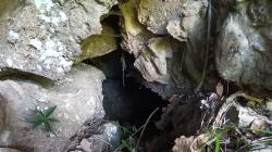
TANA DEL REBIGO
Regione
LIGURIA
Provincia
GE
Comune
NE
Areas
Size
Lenght total
15
Depth negative
1
Depth total
1
Entrance location
Latitude
44.3533798
Longitude
9.4733084
Coordinates type
Geografiche WGS84
Original coordinates type
WGS84 Generiche
Elevation
630
Location evaluation
Quota da verificare
Hydrology
temporary issuing,siphons
Trend
ORIZZONTALE
Practicability
FACILE
Description
Breve condotta che termina in un sifone
Authorphoto1
Alessandro Vernassa
Authordescription
Mario Franciscolo
Import rawdata
1{_"REGIONE":"LI","PROV":"GE","NUM":"2074","SPECIF":"0","DATAGG":null,"DRILEV":null,"NOME":"TANA DEL REBIGO","SINON":null,"RAS":null,"COMUNE":"NE","LOCAL":null,"ACAR":null,"ACARCOD":"GE36","FM":null,"FMCOD":"CAL","AGE":null,"SVILRE":"15","SVILPLAN":null,"ESTEN":null,"DPOS":null,"DNEG":"1","DTOT":"1","TC_01":"WGS84 Generiche","latitude":"44.3533798","longitude":"9.4733084","DC_01":null,"SC_01":null,"AE_01":null,"QA_01":"630","QC_01":null,"VD_01":"Quota da verificare","IDRO":"emittente temporanea,sifoni","RILEVATORI":null,"GRADORIL":null,"NOTE":null,"DATARIL":null,"NOTE2":null,"RCS":null,"DESCRIZIONE":"Breve condotta che termina in un sifone","PERCORRIBILITA":"FACILE","recordinsert":"2020-02-17 14:30:10","recordupdate":"2020-06-03 10:26:32","username":"alessandrovernassa","userupdate":"alessandrovernassa","ANDAMENTO":"ORIZZONTALE","data_verifica":null,"photo1":"Rebigo.jpeg","authorphoto1":"Alessandro Vernassa","authorDESCRIZIONE":"Mario Franciscolo"}
Dati compilazione
Recordinsert
17/02/2020
Username
alessandrovernassa
Userupdate
alessandrovernassa
Recordupdate
03/06/2020
Coordinate WGS84 (Lon,Lat):
Coordinate WGS84 (Lon,Lat):
Coordinate WGS84 UTM (x,y,zone):
Genera scheda catastale
Download update form
